Nitin Gadia
this is some of my stuff.
nittyjee@gmail.com
[Website Is Under Construction]
| CURRENT PROJECTS Mapping Early New York Rewilding Map |
| MORE MAPPING STUFF The CoronaState Project Global History Genealogy Electorates Energy |
| MORE MULTIMEDIA Writing Infographics Animated Videos |
| ONGOING PROJECTS The WindowLED Project |
| SOCIAL PROJECTS Making Place Property Coops Makerspacing Local Agriculture |
| SOME MORE WORK HISTORY |
current stuff.
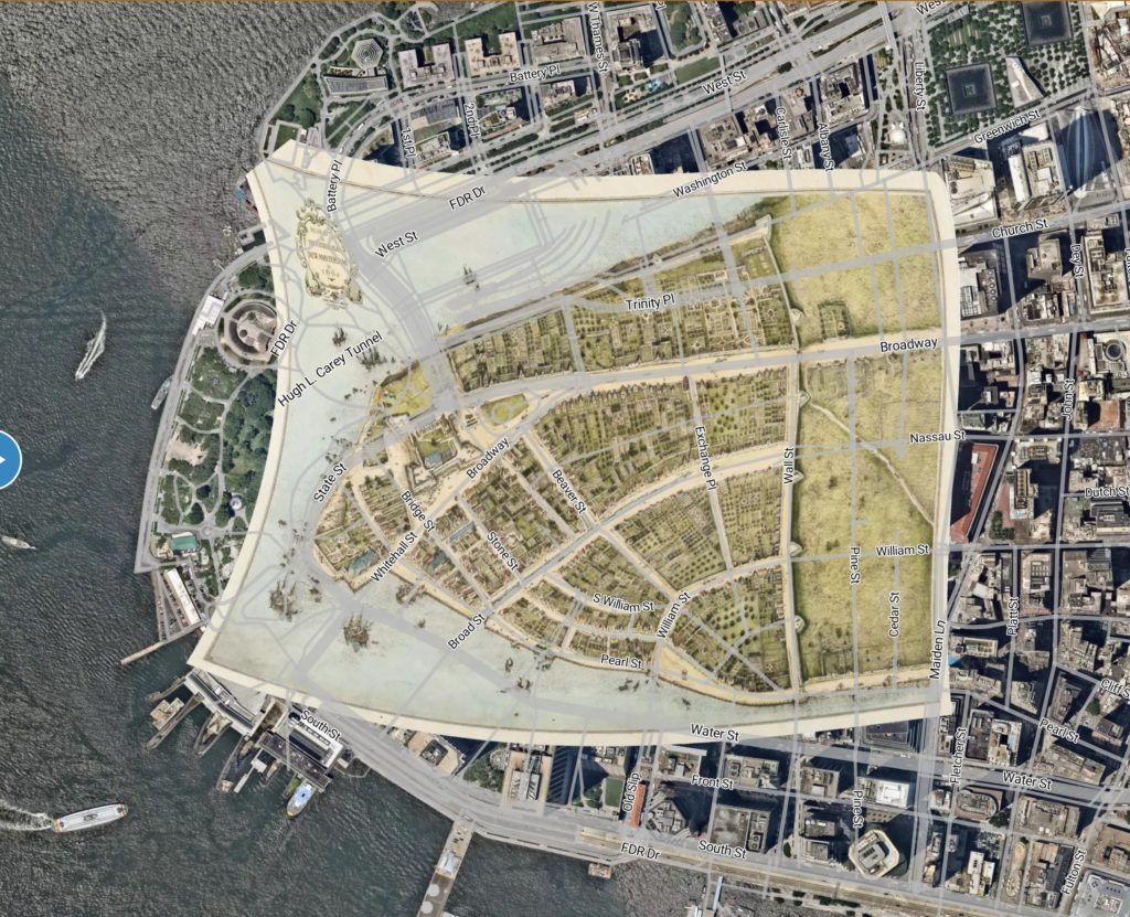
Mapping Early New York
A project with the New Amsterdam History Center (NAHC) to map the people and places in early New York. New York City was founded by the Dutch as New Amsterdam, where we have so far focused. We have completed our first phase, which was funded by the Daughters of Holland Dames. This will in the long run be a part of my larger aim to develop a platform and community around mapping global history (see further below).
We have a map and database:
https://nahc-mapping.org/mappingNY/
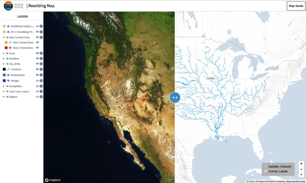
Rewilding Map
We need to make the world wild again. Politically, this is my long term #1 passion. This map is for BewildRewild, an organization devoted to rewilding Iowa and further into the Mississippi River Watershed. Explore the map – click on the guide in the upper-right and watch the overview videos.
https://bewildrewild.org/rewilding-map
More Mapping Stuff
Most of what I’ve been engaged in professionally has been with animated mapping. Until 2018 I was a data director at the MapStory Foundation, which was creating what I called a sort of “wikipedia of mapping”, where any number of people could create a map of any size that is interactive and animated.
I wrote a blog of my work while at MapStory, which is only available at the moment on the Internet Archive. Links to articles are below.
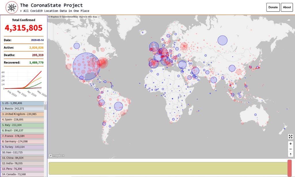
The CoronaState Project
An effort initiated in May 2020 to centralize and map all global coronavirus cases, locally. As far as I now, we are the only ones who are attempting to do this. All the other efforts do this at a national or subnational level – we’re going to get as close to individuals as possible, without violating their privacy.
This will be enormously beneficial in tracking the disease across the past and present, and seeing trends going into the future, for people in their own communities and for epidemiologists.
Our mapping interface is also more visually helpful, and includes a timeslider, and will include very helpful data visualizations for every place.
Mapping Global Human History
One of my long term dreams is the creation of a global historical map. Imagine google maps, where you can type in a year and see the way the world was then, and animate it, backwards and forwards. When I worked with MapStory, we called this “MapStory Local”.
I’ve had an application developed to demonstrate MapStory Local data. Currently it includes the United States, and Ames, Iowa, the town I grew up in, cities in the Netherlands, and the Indian Subcontinent. The platform can cover a full breadth of history, at any geographic level.
Whether it’s this application or another, a crowdmapping platform should be developed where any volunteer can contribute to the boundaries and settlements and locations people lived.
The project I’m currently engaged in is Mapping Early New York, drawing New York City from its roots, which you can read about above.
Demo: https://www.thenittygritty.org/mapstorylocal/v1.2/
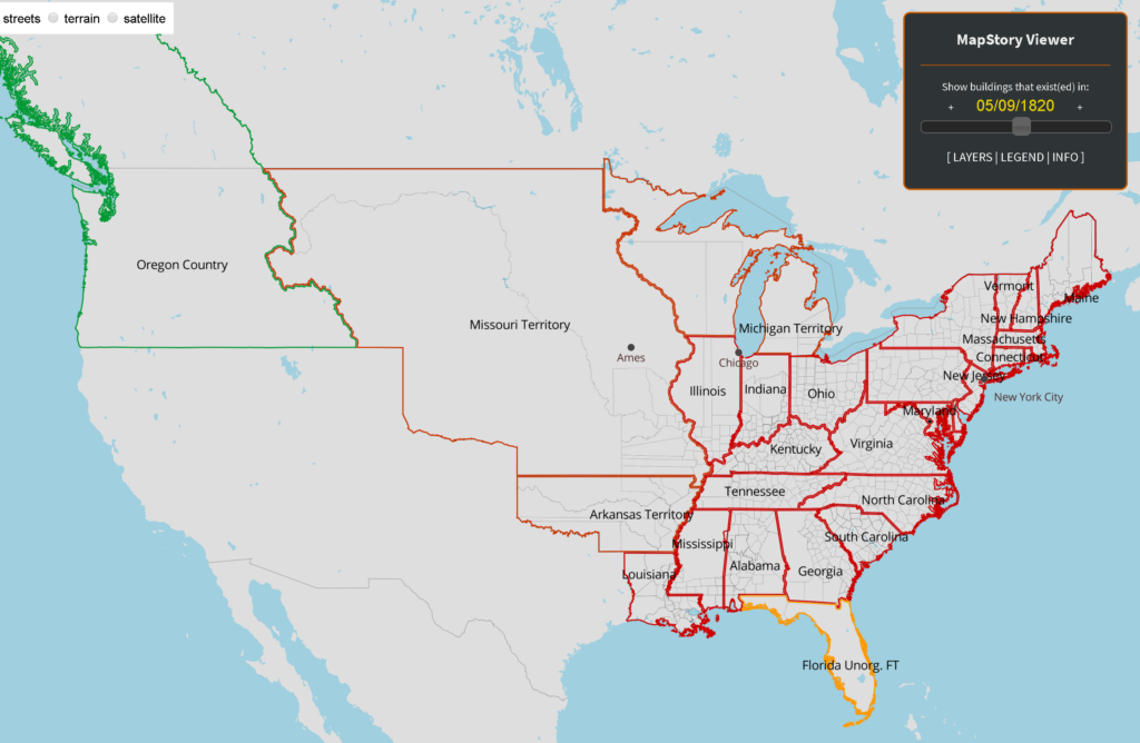
Github: https://github.com/nittyjee/temporolocal
Articles on mapping global history
Mapping Every Property in the United States
http://mapstoryblog.thenittygritty.org/every-property/
The Indian Subcontinent, 1700-2015
https://web.archive.org/web/20170629160312/http://mapstoryblog.thenittygritty.org/the-indian-subcontinent-1700-2015/
More Global History Map Animations
Indian Acquisitions and Boundaries
within US Territory (1600-2000)
Indian Subcontinent
1700-2015
More Maps
Ames Police Reports, 2012-2016
Soil Erosion
More Map Articles
Mapping All Health Issues and Disease
http://mapstoryblog.thenittygritty.org/mapping-all-health-issues-and-disease/
Are Your Taxes Paying for the Cost of Your Street?
http://mapstoryblog.thenittygritty.org/costofstreets/
Genealogy
These are, in my opinion, the most interesting maps I’ve made. With genealogy databases, we can now map everyone that’s lived for whom there’s a record of, and their relationships. This is from the largest family tree at the time, with over a hundred million people. I extracted all people who moved between generations. If a woman was born in London, and her son was born in New York, a dot would move from her birthdate in London to her son’s birthdate in New York. I had no idea what would happen, and seeing what happened these maps rendered was an incredible experience. This is a long term desire as well, which would combine with the global historic map.
Read my article on my genealogy mapping:
Mapping All of Humanity in a Single Global Family Tree
Electorates
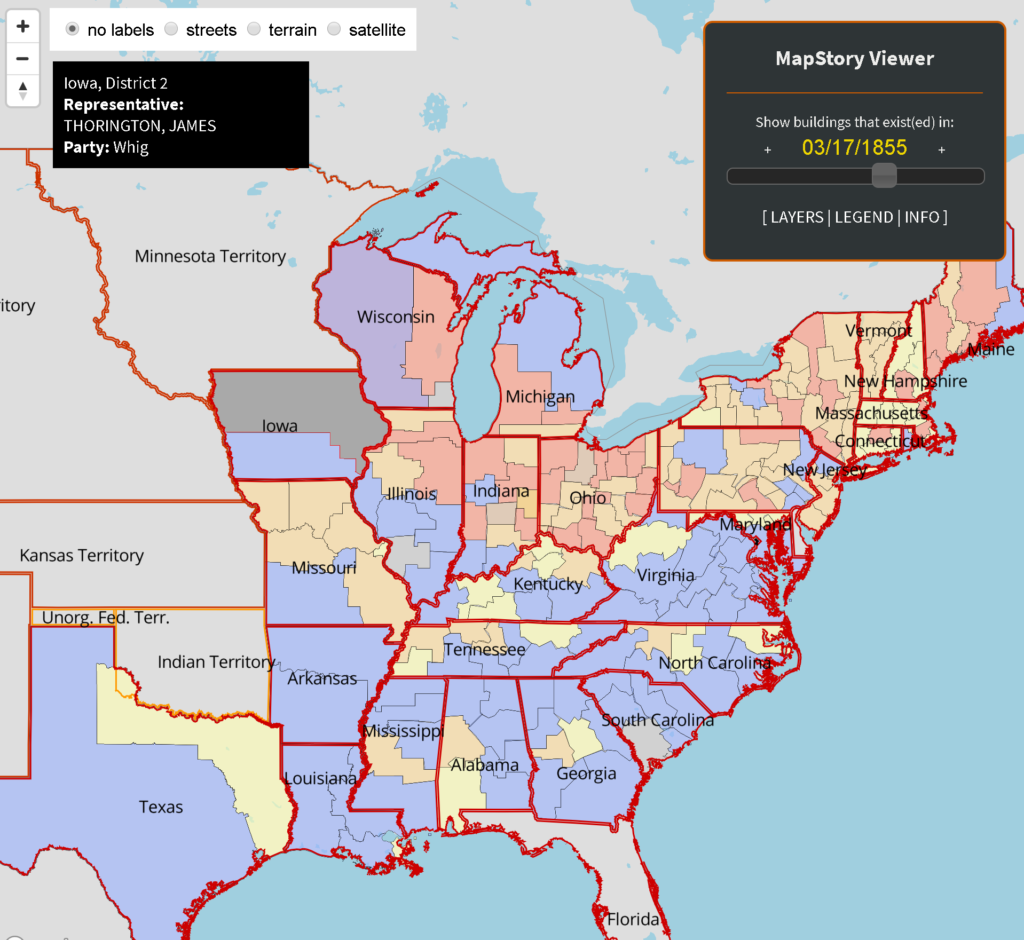
With MapStory, we worked on creating a mapstory of congressional districts, with the party and representative. Slide the slider, click on the districts. This would be a good “Electorates” global map as well, for every country that creates representative districts. In order to do this and other time mapping, I got some help from people who created some code that was added to a github repo, which is more or less universal for processing time data for mapping.
Demo: https://www.thenittygritty.org/mapstory_electorates/
Github: Universal time mapping (spatio-temporal) data tools:
https://github.com/nittyjee/Ranges-to-Rows
https://github.com/nittyjee/Timeline-to-Table
Pipelines
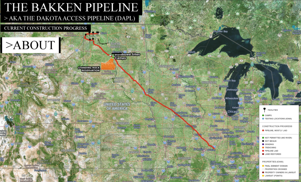
Not long after the Dakota Access Pipeline (DAPL) went by my town, I mapped it precisely, and people can locate themselves on the map. I wrote an article about it, and some of my data was used some publications. One person drove along the pipeline and met me along the way.
What emerged from this was a more political issue of the power of maps. The data is made intentionally unavailable by the US government, but all the pipelines in the world should be seen, clearly, and how they were built over time.
https://github.com/nittyjee/bakkenpipelinemap
Articles on the Map:
Mapping the Bakken Pipeline and Our “Secret” Infrastructure
Blog Post
Is the Threat of the Dakota Access Pipeline Real?
Huffington Post
Nitin Gadia
The Conflicts Along 1,172 Miles of the Dakota Access Pipeline
New York Times
(made use of data)
The man who mapped Dakota’s pipeline like a jigsaw
Reuters
Paola Totaro
More on Energy:
A Mapstory of All the Power Plants in the United States
Blog Post
more multimedia projects.
I’ve engaged in many multimedia projects, and would like to write books, accompanied by videos and graphics. My projects in general involve these communication media.
Writing
In addition to the other writing mentioned elsewhere on this page, long term, I’d like to write books on a few subjects. So far I’ve written a few in depth subjects.
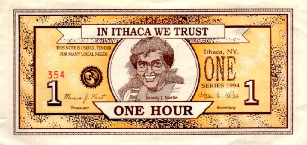
Mind Over Money
Several years ago I wrote a short 64-page booklet about complementary currencies called “Mind Over Money: An Introduction to the New Currency Revolution”. It stood on its own, but I wanted to expand it, and I might further it one day. It’s slightly outdated (bitcoin was newer then), but it’s as relevant as before. It was never published and I only shared it with a few people, but perhaps posting it here counts.
School or Education?
This is a paper that was published, dealing with the fundamental flaws of schools as a medium of learning.

Download (12,000 words, 19 pages, 8.5 x 11):
https://www.thenittygritty.org/me/wp-content/uploads/2020/05/School_or_Education_Final_Revised_8.16.11.pdf
Everybody and Nobody
This is a website I created for some of my writing years ago on decentralized, direct, self-governance of all of the aspects of industrial society. The page on transportation is particularly in depth. Some is available on the wayback machine, and will be revived one day.
https://web.archive.org/web/20160312080411/http://www.everybodyandnobody.org/
Infographics
The few in depth infographics I’ve made are rough sketches, not something I would publish. I feel hover that they are worth sharing for their content and depth.
The Average American’s Ecological Footprint
A while ago I made a mockup of a very large infographic, and hired a couple graphic designers to develop it. This is a work in progress, that will combine with a book I am planning on writing on environmental issues. The graphic is a very crude, rough mockup and not something I would publish, but if you zoom in you can see how detailed it is.
Download pdf (rough sketch):
https://www.thenittygritty.org/me/wp-content/uploads/2020/05/rearranged_2.pdf
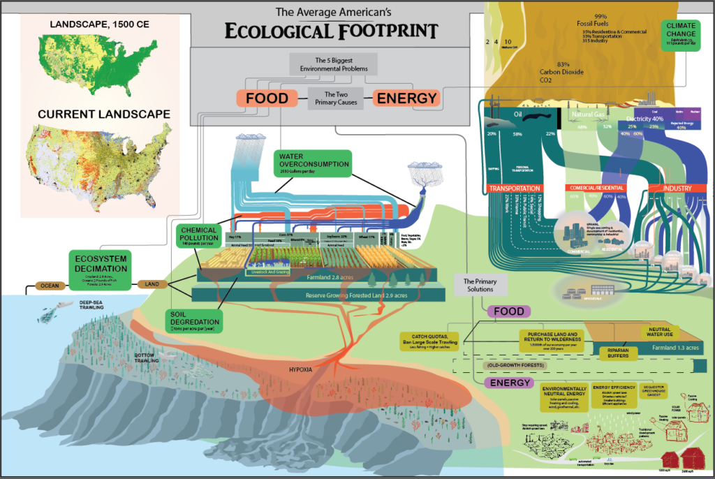
The infographic involves sankey diagrams, which I have dabbled in. I believe that once applications are further developed, sankey diagrams will revolutionize data visualization. It is possible that sankeys will become a standard for visualizing budgets for example.
Indic Traditions
This is a simple but very large flowchart I developed of the interconnectedness of Indic philosophy and beliefs. I delivered a lecture about this several years ago.
View/Download:
https://www.thenittygritty.org/me/wp-content/uploads/2020/05/Indic_Traditions_Version_0.2_png.png
Animated Videos
Before I got into mapping, I briefly started making animated videos. In addition to the other animated videos I mentioned elsewhere, here are a couple I made for some clients:
Filmmaking
Other than the small animations and documentaries I listed elsewhere and in the websites for my current and ongoing projects, I have made short films, mostly with friends, that are too inappropriate and incriminating to show here. Long run I will be making short videos and films to complement my writing. I would like to make live action films as well, but that will be a ways out.
ongoing long term stuff.
The WindowLED Floor Lamp Project
This is a floor lamp I designed / invented with engineers that goes from a dim night light (10 lumens) to as much light as the sun through an open window (10,000 lumens). No lamp goes dimmer, no lamp goes brighter, by far. If you remember those halogen floor lamps, these are the first replacements, and they go way further.
I was going to make this a kickstarter, but ended up completely open sourcing it and making a store and community around it. It’s become a side project, and have had no time to advertise it.
social projects
I believe the deeper issues within human society will be rooted out with people owning the places they live and work. Owning the companies where we work with worker owned cooperatives, such as the Mondragon Corporation, owning the land we live on, such as group equity property coops, and control of our communities by participatory, generative change.
Making Place
Half of my more political passions are in people gaining control over the communities and regions they live. I am a big follower of Christopher Alexander, who has provided a vast alternative to prescriptive planning, both by developers and planners. Long term I want to write a book on the fundamental flaws of modern planning and their successful alternatives.
My involvement has so far been with starting an effort that led to the Ames Main Street Farmer’s Market, and I was briefly involved with conversations around developing a common square in the campustown of Iowa State University. Having moved to New York City, I have only begun to settle in and not been involved with anything. However, I have begun creating a short graphic novel called “Paved: How Parking Requirements Destroyed Student Life”, which may or may not reach fruition.
I think most political issues are solved creatively, often with art, like with “tactical urbanism”, such as this street painting with Ames Street Art, which me and a friend had a city ordinance passed to create:
Property Coops
Several years ago I got interested in group equity coops. Renters form an organization and find financing to buy a house, and own it together. It’s as easy as renting, they sign a year contract, and people come and go. Eventually they pay off their mortgage and pay for upkeep. I wanted to help start one, and it still is a long term dream of mine. An idea I’ve had that I’d like to make a reality one day is an individual group equity cooperative, where people also get a share of equity.
In preparation, I made a few animated videos explaining them:
https://www.youtube.com/watch?v=Askqp1lHiXM
https://www.youtube.com/watch?v=s78wOMcQj3U
https://www.youtube.com/watch?v=CgL9WZNUaDc
Makerspacing
Years ago got fascinated by “Fab Labs”, and went to a symposium where I learned about “hackerspaces”. Eventually I started Ames MakerSpace with some people who became my friends through the process. The space meets every Thursday evening. We disussed many things and they helped me with many projects. One major project came out of it that is still ongoing, the WindowLED project, mentioned above.
The symposium I went to was creating the US Fab Lab Network, and made a short video of my experiences. These are a bit crude and dull, but they did involve some skill.
Part 1: https://vimeo.com/7811586
Part 2: https://vimeo.com/7809903
Local Agriculture
Years ago I was interested in local farming, because that’s where greater empowerment lies. I still am in it long term, I’d like a very large garden at least. I worked on an urban farm in Milwaukee called Growing Power.
I had a food blog: https://growingmyfood.wordpress.com/
In 2009 I initiated an effort that led to the creation of the Ames Main Street Farmers Market, bringing farmers and a local food coop and businesses together.
Other Work History
For most of my working life, I’ve been self-employed, but I have had very valuable experiences working elsewhere. I worked at a patent marketing firm, an urban farm (mentioned elsewhere), a residential treatment center for children, a daycare, volunteered at an assault care shelter, and have had brief odd jobs here and there in food service.